
Offering Details
Back
Current Offerings / Bounty Developments Ltd.
Bounty Developments Ltd.
 Property Divestiture
Bid Deadline: December 3, 2026
12:00 PM
Download Full PDF - Printable
OVERVIEW
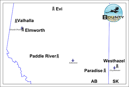
Bounty Developments Ltd. (“Bounty” or the “Company”) has engaged Sayer Energy Advisors to assist the Company with the farmout or sale of its oil and natural gas interests located in the Elmworth, Evi, Paddle River, Paradise and Valhalla areas of Alberta and the Westhazel area of Saskatchewan (the “Properties”).
The Properties consist of predominantly 100% working interests in Crown mineral rights with prospective drilling locations for oil and natural gas primarily in the Montney, Charlie Lake, Ostracod, Sparky and Cummings formations. Additionally, Bounty is selling two light oil wells in the Evi area of Alberta targeting the Granite Wash Formation.
At Elmworth, Bounty has a 100% working interest in 5.75 sections of land: three sections with P&NG rights from surface to basement, two sections with rights from surface to the base of the Charlie Lake Formation and three-quarters of a section with rights from surface to the base of the Halfway Formation. These sections are highly prospective for multiple pay sequences in the Montney and Charlie Lake formations.
In the Evi area, Bounty holds a 100% working interest in 2 Granite Wash light oil wells. One well produces at a rate of approximately 10 bbl/d oil while the other is shut-in, requiring a tubing repair having last produced at stable rate of approximately 15 bbl/d of oil. The wells have ample remaining reserves and access to nearby battery and services, with potential for optimization through a local, experienced operator.
At Paddle River, Bounty holds a 100% working interest in an aggregate of 2 sections of land, with P&NG rights from surface to basement. These lands are offsetting production from, and highly prospective in, the Ostracod Sandstone Formation.
In the Paradise area, Bounty holds a 100% working interest in 2.5 sections of land, with PNG rights from surface to base of Prairie Evaporite Formation. These lands are offsetting production from, and highly prospective in, the Lower Cretaceous Cummings Sandstone Member.
At Valhalla, Bounty has a 100% working interest in an aggregate of 3 sections of land, with P&NG rights to the Charlie Lake and Halfway formations. These lands are highly prospective for multiple pay sequences in the Charlie Lake and Halfway formations.
In the Westhazel area of Saskatchewan, Bounty holds 9 LSDs of land, with PNG rights from surface to top of the Prairie Evaporite Formation. These lands are suitable for multilateral horizontal drilling in the undrained portion of a Sparky oil pool.
Further geological details of the Properties will be available in the virtual data room for parties that execute a confidentiality agreement.
Overview Map Showing the Location of the Divestiture Properties
Liability Assessment Summary
Bounty has an interest in two oil wells at Evi. As of October 1, 2026, the Evi property had a deemed liability value of $226,852.
Seismic Overview
The Company does not have ownership in any seismic data relating to the Properties.
Reserves Overview
Bounty does not have a third-party reserve report.
Bounty has an interest in two oil wells at Evi. As of October 1, 2026, the Evi property had a deemed liability value of $226,852.
Seismic Overview
The Company does not have ownership in any seismic data relating to the Properties.
Reserves Overview
Bounty does not have a third-party reserve report.
ELMWORTH
Township 70-71, Range 5 W6
Elmworth Charlie Lake
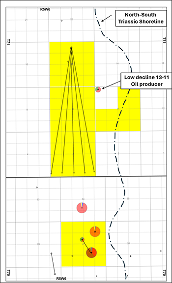
At Elmworth, Bounty holds a 100% working interest in 4.75 sections of Charlie Lake rights. Vertical production and mapping indicate large, undrained sandstone and dolomite reservoirs containing 40° API oil and sweet natural gas following a north-south trending shoreline.
Elmworth Charlie Lake
At Elmworth, Bounty holds a 100% working interest in 4.75 sections of Charlie Lake rights. Vertical production and mapping indicate large, undrained sandstone and dolomite reservoirs containing 40° API oil and sweet natural gas following a north-south trending shoreline.
Large Undrained Northern Pool
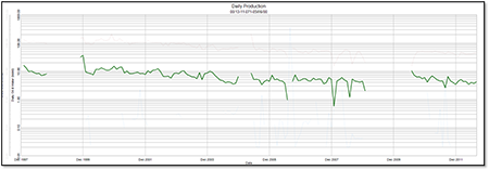
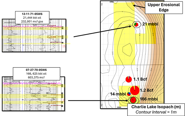
Bounty’s lands are situated on a north-south Charlie Lake trend thick with three oil-bearing pay sequences. As shown in the following production plot, the offsetting well 100/13-11-071-05W6/0 shows a flat production trend, suggesting a larger, undrained pool on Bounty’s lands. These porous sequences are stratigraphically equivalent to the sequences that produced 166 Mbbls of light oil to the south from the 100/07-27-070-05W6/0 well. High permeability is indicated through core and production results from perforation only. The southern pool indicates an up-dip natural gas cap with high liquids content, which is ideal for fuel natural gas for gas-to-power.
Bounty’s lands are situated on a north-south Charlie Lake trend thick with three oil-bearing pay sequences. As shown in the following production plot, the offsetting well 100/13-11-071-05W6/0 shows a flat production trend, suggesting a larger, undrained pool on Bounty’s lands. These porous sequences are stratigraphically equivalent to the sequences that produced 166 Mbbls of light oil to the south from the 100/07-27-070-05W6/0 well. High permeability is indicated through core and production results from perforation only. The southern pool indicates an up-dip natural gas cap with high liquids content, which is ideal for fuel natural gas for gas-to-power.
100/13-11-071-05W6/0
Low Decline Oil Producer
Low Decline Oil Producer
2-Leg Open Hole Stacked Horizontal Location
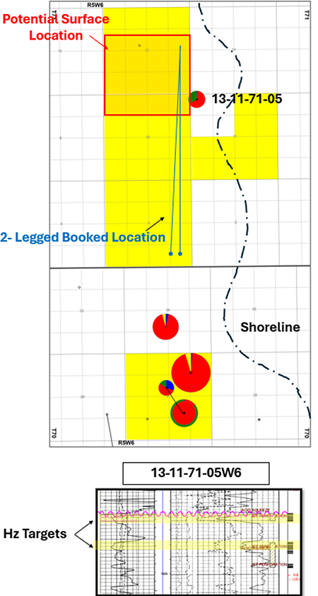
A potential low-cost open hole location would offset proven reservoirs found in the 100/13-11-071-05W6/0 well by targeting two thicker pay sequences. A potential well would target the two thicker pay sequences (identified below). An area access assessment has identified a large area of amenable surface locations in Sections 15 and 10 for north-south wells and surface equipment. Potential natural gas egress via gas-to-power exists with proximal fiber optic lines for AI generation. Drilling costs are estimated to be approximately $2.5 million for a 2-leg open hole well in the area. This location has expected initial production rates of 900 bbl/d of oil and 800 Mcf/d of natural gas based on lower permeability analog pads operated by Prairie Thunder Resources Ltd. at Cecil, which target stratigraphically equivalent members.
A potential low-cost open hole location would offset proven reservoirs found in the 100/13-11-071-05W6/0 well by targeting two thicker pay sequences. A potential well would target the two thicker pay sequences (identified below). An area access assessment has identified a large area of amenable surface locations in Sections 15 and 10 for north-south wells and surface equipment. Potential natural gas egress via gas-to-power exists with proximal fiber optic lines for AI generation. Drilling costs are estimated to be approximately $2.5 million for a 2-leg open hole well in the area. This location has expected initial production rates of 900 bbl/d of oil and 800 Mcf/d of natural gas based on lower permeability analog pads operated by Prairie Thunder Resources Ltd. at Cecil, which target stratigraphically equivalent members.
Elmworth Montney
Bounty holds a 100% working interest in 3 sections of land with P&NG rights from surface to basement. These 3 sections are adjacent to a substantial Whitecap Resources Inc. position, and contain Montney turbidite deposits, along a rich, high silica content fairway shared with the Gold Creek development that has yielded oil rates of over 1,700 bbl/d with drilling density of 5 wells across three-sections.
Bounty holds a 100% working interest in 3 sections of land with P&NG rights from surface to basement. These 3 sections are adjacent to a substantial Whitecap Resources Inc. position, and contain Montney turbidite deposits, along a rich, high silica content fairway shared with the Gold Creek development that has yielded oil rates of over 1,700 bbl/d with drilling density of 5 wells across three-sections.
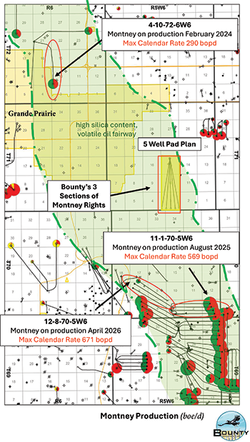
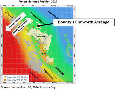
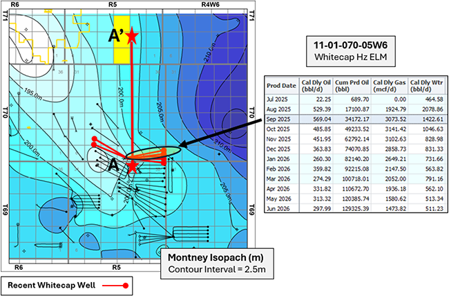
The recent success of Whitecap’s wells is extending development to the NW along this fairway. Area operators are utilizing elevator frac technology in additional vertical benches, capturing hydrocarbons in high silica content turbiditic Montney. Bounty’s lands at Elmworth fall within this high sand content portion. The lands have turbidite deposits with rock and pressures that are favourable for the current two bench frac development.
The Bounty land portion of the Montney bench contains middle and upper Montney zones within a sweet spot that enables the exploitation of reserves in both benches through one long vertical frac. This prolific fairway has Montney rock that is within the volatile oil window, a normally pressured hydrocarbon-bearing upper sand and the high in silica content that enables far frac propagation.
Whitecap’s pad locations along this fairway also demonstrate how wells along this trend allow for tight horizontal spacing of 4-5 wells per section. The wells have 2 to 3-mile horizontal lengths with 400m interwell spacing.
Gold Creek Comparison
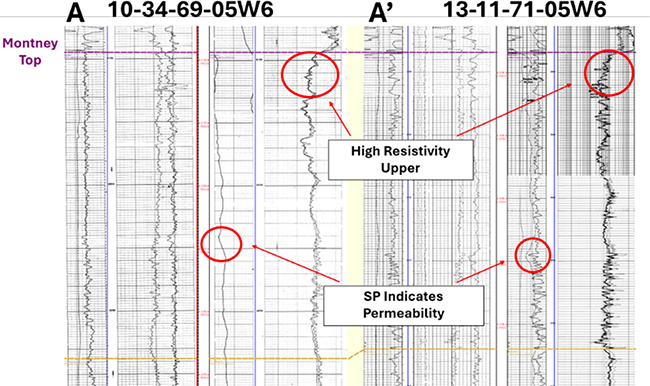
The following cross-section A to A’ indicates that the high silica content, and high permeability turbidite deposits seen in Whitecap’s recent offsetting development is comparable to the reservoir found on Bounty’s lands.
The analog control well 100/13-11-071-05W6/0 shows the strong permeability responses in the middle Montney with high resistivity porosity in the upper Montney and a high silica content between the zones.
Cross-section A-A'
VALHALLA
Township 75, Range 10 W6
Charlie Lake & Halfway Formations
At Valhalla, Bounty holds a 100% working interest in an aggregate of 3 sections of land, with P&NG rights in the key target zones Charlie Lake (excluding the ¼ section identified in red below) and Halfway. Both formations are on trend with a productive fairway with multiple well locations having 500 bbl/d plus oil potential.
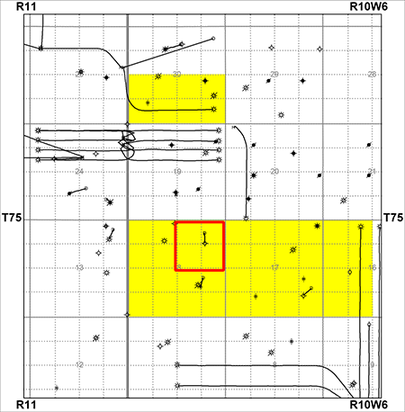
Charlie Lake Valhalla Member
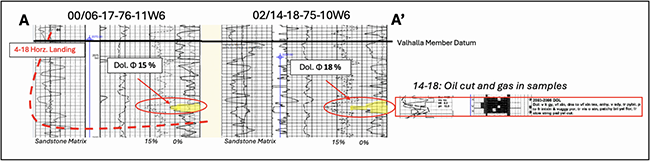
On Bounty’s lands, the Valhalla Member is defined as having a large areal extent, oil staining/cuts on samples, as well as high porosity and permeability indicators on logs. Bounty interprets its lands to have comparable reserves to top tier production.
The offset Valhalla member well 100/04-18-076-11W6/0 demonstrates the productivity of this fairway (up to 1,097 bbl/d of oil). Recent drilling activity by Advantage Energy Ltd. northwest of Bounty’s lands also targets the Charlie Lake Valhalla Member and provides additional control along the interpreted trend. Continuation of this potential southeast toward Bounty’s lands is supported by oil shows, porosity and strip-log character analogous to high-rate producers.
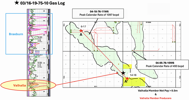
Valhalla Member Cross-Section A-A'
Charlie Lake Braeburn Member
In the Braeburn Member, Bounty lands have greater net pay and, in some cases, double the number of pay sequences than the offset well 100/13-18-076-09W6/0 which peaked at a rate of 1,105 bbl/d of oil. These multiple Braeburn sequences have produced light oil and also map favourably across the Bounty lands.
In the Braeburn Member, Bounty lands have greater net pay and, in some cases, double the number of pay sequences than the offset well 100/13-18-076-09W6/0 which peaked at a rate of 1,105 bbl/d of oil. These multiple Braeburn sequences have produced light oil and also map favourably across the Bounty lands.
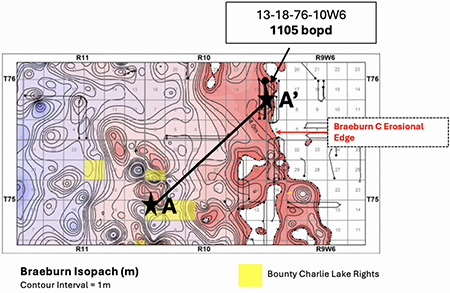
Braeburn Cross-Section A-A'
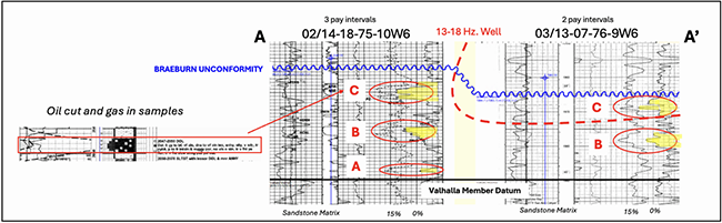
Demonstrates greater thickness of reserves on Bounty lands than the 1,105 bbl/d oil well
Valhalla - Halfway
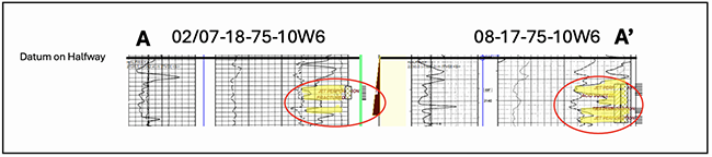
At Valhalla, the Halfway zone has proven natural gas production with high liquids content as demonstrated by vertical production. The vertical well 102/07-18-75-10W6/0 produced 751 MMcf of natural gas and 3.7 Mbbls of condensate from the Halfway and was still producing at a rate of approximately 210 Mcf/d of natural gas prior to being shut-in. There are two shut-in natural gas wells (100/08-17-075-10W6/0 and 102/07-18-075-10W6/0) on Bounty lands which produced the highest liquids content for the area. The Halfway presents an excellent liquids rich horizontal target for multiple 1 to 2-mile long drilling locations.
At Valhalla, the Halfway zone has proven natural gas production with high liquids content as demonstrated by vertical production. The vertical well 102/07-18-75-10W6/0 produced 751 MMcf of natural gas and 3.7 Mbbls of condensate from the Halfway and was still producing at a rate of approximately 210 Mcf/d of natural gas prior to being shut-in. There are two shut-in natural gas wells (100/08-17-075-10W6/0 and 102/07-18-075-10W6/0) on Bounty lands which produced the highest liquids content for the area. The Halfway presents an excellent liquids rich horizontal target for multiple 1 to 2-mile long drilling locations.
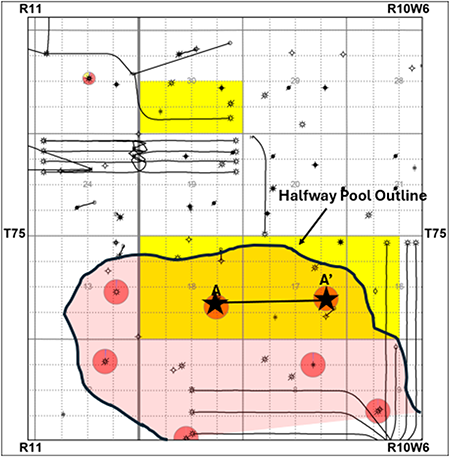
Halfway Cross-Section A-A'
PADDLE RIVER
Township 55, Range 7 W5
Ostracod Sandstone
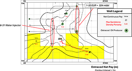
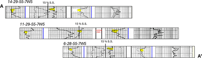
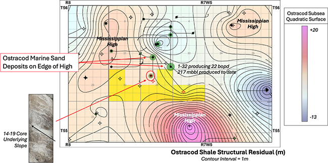
At Paddle River, Bounty holds an aggregate two sections of land which contain the southern extension of a marine Ostracod sandstone oil pool (Paddle River Ostracod A). The Ostracod A pool is interpreted as a marginal-marine shoreface deposit containing 30° API oil at the shallow target depth of approximately 1,537 m TVD. This opportunity features a 1-2 m net oil-bearing reservoir with up to 16% density porosity. The wells 100/01-32-055-07W5/0 and 100/14-29-055-07W5/2 are active producers, directly offsetting Bounty’s acreage in Section 29-055-07W5. Both wells show pressure support from the 100/08-31-055-07W5/0 water injector. Decline analysis of the 1-32 well, which has already produced 217 Mbbls of oil, indicates an ultimate recovery of 324 Mbbls of oil. The following cross-section A to A’ demonstrates how the target sand maps southeast and southwest following the structural slope along underlying Mississippian highs.
Ostracod Cross-Section A-A'
Analog Producer 100/07-02-048-04W4/0
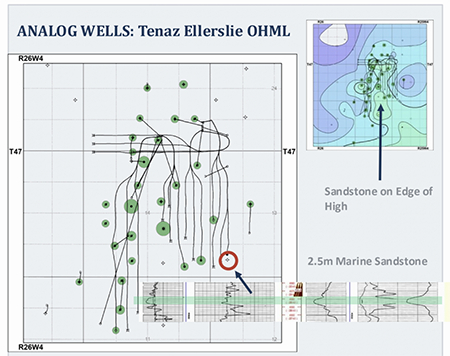
The Ostracod A pool has had success with horizontal development with a north-to-south frac’d well (100/01-32-055-07W5/0 with peak rates of 432 bbl/d of oil and estimated ultimate recovery of 324 Mbbls of oil). With ongoing industry success through multi-leg horizontal drilling, Bounty has identified an analog well drilled in a similar geological environment in Wizard Lake (Township 47, Range 26 W4) where a recent successful pad was completed with open hole multi-laterals targeting approximately 2 m Ellerslie marine sands. The best well, 100/01-14-047-26W4/0, achieved a peak rate of 375 bbl/d of oil, demonstrating an effective development method for thin marine sandstone as in the Paddle River Ostracod A.
The Ostracod A pool has had success with horizontal development with a north-to-south frac’d well (100/01-32-055-07W5/0 with peak rates of 432 bbl/d of oil and estimated ultimate recovery of 324 Mbbls of oil). With ongoing industry success through multi-leg horizontal drilling, Bounty has identified an analog well drilled in a similar geological environment in Wizard Lake (Township 47, Range 26 W4) where a recent successful pad was completed with open hole multi-laterals targeting approximately 2 m Ellerslie marine sands. The best well, 100/01-14-047-26W4/0, achieved a peak rate of 375 bbl/d of oil, demonstrating an effective development method for thin marine sandstone as in the Paddle River Ostracod A.
PARADISE
Township 47-48, Range 3-4 W4
Cummings Sandstone
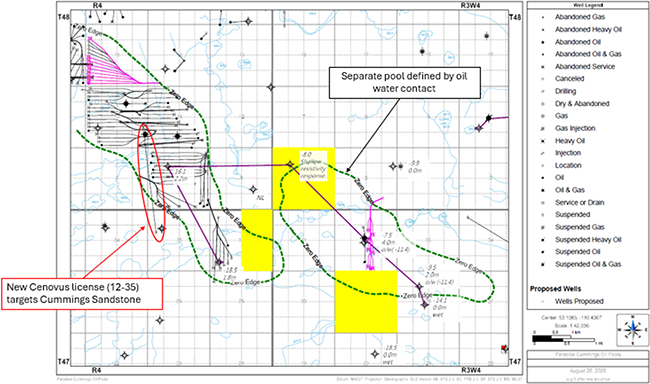
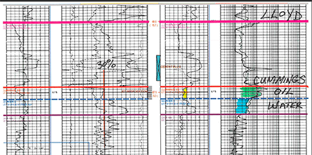
Bounty's acreage offers a Lower Cretaceous Cummings Sandstone Member oil pool. It is interpreted as a marginal-marine shoreface deposit containing heavy 12° API oil at the shallow target depth of approximately 673 m TVD. Two separate oil pools are outlined by dashed green contours, featuring oil pay ranging from 1.8 m to 4.0 m with 30% porosity and identified as distinct by different oil water contacts. Recent open-hole horizontal drilling activity, highlighted in pink adjacent to Bounty’s acreage, underscores the potential for expanded open-hole horizontal drilling. Furthermore, Cenovus Energy Inc.’s recent well licensed at 102/12-35-047-04W4/0 demonstrates active development by industry.
100/11-32-047-03W4/0 Type Log
Analog Producer 100/07-02-048-04W4/0
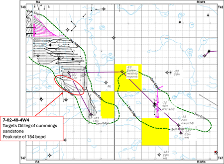
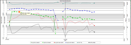
The offset well 100/07-02-048-04W4/0 came on production in August 2023 and achieved peak rates of 154 bbl/d of oil, targeting the upper oil leg of the Cummings Sandstone Pool J. Decline analysis projects an estimated ultimate recovery of 133 Mbbls of oil.
The offset well 100/07-02-048-04W4/0 came on production in August 2023 and achieved peak rates of 154 bbl/d of oil, targeting the upper oil leg of the Cummings Sandstone Pool J. Decline analysis projects an estimated ultimate recovery of 133 Mbbls of oil.
100/07-02-048-04W4/0
Calendar Daily Oil vs Time
EVI
Township 86, Range 12 W5
Granite Wash Light Oil Wells - 100/08-22-86-12W5/0 & 102/12-23-86-12W5/0
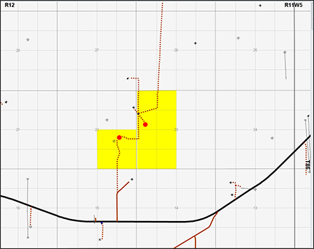
At Evi, Bounty holds a 100% working interest in two Granite Wash light oil (38.1° API) wells located at 100/08-22-86-12W5/0 and 102/12-23-86-12W5/0. The wells are situated on the southeast quarter of Section 22 and the west half of Section 23-86-12W5. Mineral rights held are Crown in the Granite Wash zone. The wells are located one mile north of Highway 986 with good access to the lease by gravel road.
The 08-22 well qualifies to conversion from Alberta Royalty Framework (“ARF”) to Modernized Royalty Framework (“MRF”) royalty regime effective Jan 1, 2027 (reduced royalty).
The Evi property includes light sweet oil of 38.1o API with low sulphur and high fluid levels. The large pumping system and increased storage capacity aids in increased oil rates. The property has good access to the Spoke Resources Ltd. battery located at 04-36-086-11W5, area services and is near the town of Red Earth. Spoke treating / water disposal fees have been reduced by approximately 20% effective Jan 1, 2026 and are now reflected in 2026 operating costs.
Increased storage capacity and inclusion of wells with other area wells has led to reduced downtime at Evi. The conversion of shut-in area wells to water disposal and/or delivery of water to other locations would reduce costs.
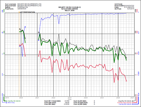
The well 102/12-23-086-12W5/0 well is currently producing at 10 bbl/d of oil at a 93-95% watercut. The production is tank treated with water and emulsion shipped to the Spoke battery at 04-36-086-11W5. The Spoke battery is connected to an oil sales pipeline and water disposal system. The 02/12-23 well is equipped with two 750 bbl and two 400 bbl tanks on site for storage. The well is on pump and equipped with a 640 PJ unit and a natural gas fired engine. The royalties for the 02/12-23 well fall under the MRF.
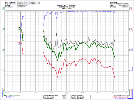
The well 100/08-22-086-12W5/0 is currently shut-in requiring a tubing repair and last produced at a rate of approximately 15 bbl/d of oil at a 90% watercut. The last date of production was February 2026. The 08-22 well is on pump and equipped with a 640 PJ unit and a natural gas fired engine. The royalties for the 08-22 well fall under the ARF up to December 31, 2026 (MRF thereafter).
Evi Liability Assessment
As of October 1, 2026, the Evi property had a deemed liability value of $226,852.
As of October 1, 2026, the Evi property had a deemed liability value of $226,852.
WESTHAZEL, SK
Township 50, Range 22-23 W3
Sparky Sandstone
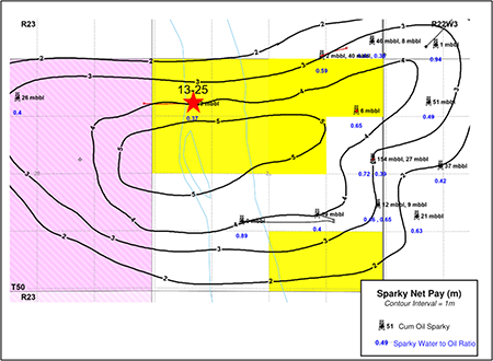
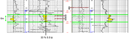
At Westhazel, Bounty holds 9 LSDs of land, with PNG rights from surface to top of the Prairie Evaporite Formation. The lands offer a 3 to 5 m thick Sparky sand with 34% porosity and higher 14° API oil cuts, in the un-drained portion of the pool. Vertical drilling density of the pool to the northeast reaches one well per LSD while Bounty’s portion of the pool is much less drained with one well per quarter. The key well 191/13-25-050-23W3/0 produced 32 Mbbl of oil with a 63% oil cut (the highest in the section) from the perforated 6 m gross thick sandstone interval starting at 403 m TVD. Low gamma ray and high resistivity measurements in lower pay sequence demonstrates a reservoir of coarse grained, high silica content sandstone with excellent permeability.
Key Well 91/13-25-050-23W3/0
Sparky Sandstone Target
Westhazel Preliminary Multilateral Development Plan
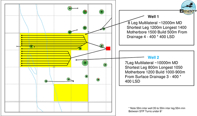
The development plan by heavy oil multi-lateral specialist Copper Creek Geologic Consulting Ltd. illustrates two multilateral Sparky wells targeting the thick high oil cut, undrained portions of the pool. Well 1 comprises eight legs and approximately 12,000 m MD, with individual legs of approximately 1,200–1,400 m and a 1,500 m motherbore and toe down at 101.0m SS. Well 2 comprises seven legs and approximately 10,000 m MD, with individual legs of approximately 800–1,050 m and a 1,200 m motherbore, approximately 50 m between wells, and 35–50 m between legs and toe down at 100.0m SS.
The development plan by heavy oil multi-lateral specialist Copper Creek Geologic Consulting Ltd. illustrates two multilateral Sparky wells targeting the thick high oil cut, undrained portions of the pool. Well 1 comprises eight legs and approximately 12,000 m MD, with individual legs of approximately 1,200–1,400 m and a 1,500 m motherbore and toe down at 101.0m SS. Well 2 comprises seven legs and approximately 10,000 m MD, with individual legs of approximately 800–1,050 m and a 1,200 m motherbore, approximately 50 m between wells, and 35–50 m between legs and toe down at 100.0m SS.
Copper Creek Geologic Consulting Sparky 2-Well Drill Plan
PROCESS & TIMELINE
Sayer Energy Advisors is accepting proposals relating to this process until 12:00 pm on Thursday, December 3, 2026.
Sayer Energy Advisors does not typically conduct a "second-round" bidding process; the intention is to attempt to conclude
transaction(s) with the party(ies) submitting the most acceptable proposal(s) at the conclusion of the process.
transaction(s) with the party(ies) submitting the most acceptable proposal(s) at the conclusion of the process.
Sayer Energy Advisors is accepting proposals from interested parties until
noon on Thursday, December 3, 2026.
NOTE REGARDING A SAYER PROCESS
On each and every offering brochure generated by Sayer, you will note the sentence “Sayer Energy Advisors does not conduct a “second-round” bidding process; the intention is to attempt to conclude a sale of the Properties with the party submitting the most acceptable proposal at the conclusion of the process.” What this means is that Sayer will not go back to multiple parties at the same time after bids are received, asking them all for a second bid. We determine which party submitted the most acceptable proposal and then we attempt to negotiate acceptable terms with that party in a “one-off” situation.
If the process involves a cash sale of a property or company and the party which submitted the most acceptable proposal has met our client’s threshold value, that offer will be accepted. If this proposal does not meet our client’s threshold value, then we will advise that party that the offer is not quite what our client was expecting, and we will ask them to increase the offer. If that offer is not acceptable to our client, we will then move down to the party which submitted the next most acceptable proposal and we will then work with that party to attempt to meet our client’s threshold value.
In the extremely rare circumstance where two or more parties submit virtually identical proposals, we will contact all parties, we will advise them of this situation and we will ask them to submit a revised proposal. Once these are received, we will work with the party which has submitted the most acceptable proposal.If the process involves a cash sale of a property or company and the party which submitted the most acceptable proposal has met our client’s threshold value, that offer will be accepted. If this proposal does not meet our client’s threshold value, then we will advise that party that the offer is not quite what our client was expecting, and we will ask them to increase the offer. If that offer is not acceptable to our client, we will then move down to the party which submitted the next most acceptable proposal and we will then work with that party to attempt to meet our client’s threshold value.
CONFIDENTIALITY AGREEMENT
Parties wishing to receive access to the confidential information with detailed technical information relating to this opportunity should execute the Confidentiality Agreement and return one copy to Sayer Energy Advisors by courier, email (brye@sayeradvisors.com) or fax (403.266.4467).
Included in the confidential information is the following: mineral property reports, geological presentations, deemed liability information and other relevant technical information.
Download Confidentiality Agreement
To receive further information on the Properties please contact Ben Rye, Tom Pavic or Sydney Birkett at 403.266.6133.